


 restoring an ancient stream in central seoul.
much has been written about the cheonggyecheon (청계천), the 5.8-km restored stream that magically starts in the heart of downtown seoul and courses through the neighborhoods of jongno and dongdaemun before it meets the jungnangcheon (중랑천) and eventually empties into the han river. a snapshot i took on a nice day last fall when i skipping korean class.
completed in 2005, the restoration of the historic waterway was a major success for then seoul mayor (now president) lee myung-bak. it gave the former hyundai construction executive international plaudits and "green" credentials as the cheonggycheon was regarded by many as a major success in urban renewal and beautification. but beauty didn't come cheap. the initial price tag was estimated to be 900 billion won (approx. $900 million), but an additional $12 trillion won is expected to redevelop the adjacent neighborhoods into major commercial and residential areas. since joseon times, the cheonggyecheon played a major part in seoulites' lives (from here).
although recent history saw the cheonggyecheon paved over by a concrete expressway, the "clean stream" as the translation goes, is older than the 600-year-old city itself. before seoul (then hanyang) became the joseon dynasty's capital in the late 14th century, the cheonggyecheon (originally known simply as "gaecheon" or "a stream") was one of several naturally formed streams that drained the ring of mountains into the han river. in 1406, king taejong ordered the stream dredged to temper the seasonal flooding that plagued his new fortress city's residents. although its geomantic value (known in korean as pungsu) suggested the stream should be kept clean, from early days until recently, practicality made the cheonggyecheon a primary way to dispose of wastewater. in the aftermath of war the area beside the cheonggyecheon became a stinky slum (from here).
during the japanese colonial period, the stream was renamed "cheonggyecheon" and became the border between the jongno neighborhood and honmachi, a japanese town. following liberation in 1945 and the korean civil war (1950-53), the area became a large slum. soon, the "clean stream" was filled with human waste, trash and rising sediment and emitted a pervasive stench. later that decade, as seoul began its rapid industrialization, the stream was paved over and the slums were destroyed. in 1968, an elevated highway was constructed over the old streambed, and in the 80s and 90s, the area became the noisy and dusty commercial center of seoul. then and now.
in 2003, with an eye towards making seoul a more environmentally-friendly and livable city, the cheonggyecheon restoration project got underway. and, nearly three years since completion, the cheonggyecheon is widely viewed as a big success. that said, the project caused considerable opposition and controversy by displaced merchants and a previous mayor, who feared (rightly so) that the project would accelerate gentrification in the area. furthermore, a few months prior to its completion, then-mayor lee myung bak's vice mayor and another political hack were arrested on bribery charges in connection with the project.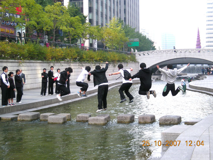 kids are cute.
nowadays, each week, over 500,000 people walk alongside the 120,000 tons of water that are pumped into the old streambed. in the mornings, groups of brightly-clad ajummas powerwalk along the paths while lovebirds walk slowly arm-in-arm at night when the banks are lit up. there's also a growing number of fish and birds returning to the stream, including a few bright orange goldfish i saw on a recent trip... no doubt the stream has become a favorite place for kids to release their pets.
anyhow, if you plan to make a visit, interspersed among the route's 22 bridges are several sights worth mention:
cheonggye plaza
this plaza marks the cheonggyecheon's starting point. a colorful spiral sculpture, a miniature etching of the stream, and a grand waterfall and fountain meet stones from eight provinces symbolizing harmony and eventual korean reunification.
location: prior to mojeon bridge (#1)
gwangtonggyo
this ancient bridge was built during the early joseon dynasty and was the ancient city's largest stone bridge. its current placement is approx. 150m from its original location.
location: it is bridge #2
banchado
a 192-meter long illustration of a visit by king jeongjo to suwon castle, painted on 5,120 ceramic tiles.
location: between gwang (#3) and samil (#5) bridges.
laundry site
this laundry site is a reminder of the stream's value for ordinary citizens for centuries.
location: between dasan (#16) and yeongdo (#17) bridges.
wall of hopes
20,000 citizens decorated 10 x 10 cm ceramic tiles with written wishes and drawings that decorate both sides of the stream.
location: between hwanghak (#18) and biudang (#19) bridges
jonchigyogak
these remaining piers are all that's left of the ugly old expressway that was replaced. it's one of my favorite elements.
location: just before muhak bridge (#20)
cheonggycheon culture center
a 6-story structure featuring an seminar rooms and exhibits on the stream's past and present.
location: straddling gosanja bridge (#22)
willow wetland
a wetland reclamation area featuring pussy willows, river bulrush and iris was planted to secure habitats for fish, birds and amphibians.
location: after gosanja bridge (#22)
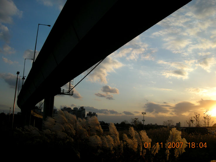 sunset near where the cheonggyecheon and jungnangcheon meet.
getting there:
→ take subway line 1 or 2 to city hall station (exit #4). walk 250m north to cheonggye plaza.
→ take subway line 5 to gwangwhamun station (exit #5). walk 100m south to cheonggye plaza.
→ note: subway line 1 runs along much of the stream's north bank from city hall station to sinseol-dong station. subway line 2 runs along much of the stream's south bank from city hall station to hanyang university station, as well as along its east bank.
5 comments:
Excellent post, I love the photo of the kids jumping.
I always meant to write up a post on Cheonggyechoen, but I never got round to it. Now I don't need to. I'll just post a link to this one!
Tokyo City government is considering doing something similar here to replace some of the crumbling network of elevated expressways that criss cross the city built in the 60's. I know they've been to Seoul to take notes.
Blogger is supid.
The "email follow up comments " is not there if you've not logged in.
hi jon,
thanks for the comment and for linking. i just found some more good old photos that i plan to post shortly.
viagra strips where to buy viagra viagra alternative cheap viagra canada legal viagra free viagra in the uk problems with viagra cheap herbal viagra viagra lawyer columbus viagra prescription uk how to buy viagra purchase viagra buy sublingual viagra online viagra price comparison
I look forward to reading more on the topic in the future. Keep up the good work! This blog is going to be great resource. Love reading it.
Post a Comment